Regardless of whether you agree, disagree or were brought to your knees laughing with tears streaming down your face, after reading our previous post... the potential destruction and loss of lives - however it is caused - should be something the media addresses instead of the latest Hollywood scandels that make headline news.
The Director of Tennessee's County Office of Preparedness Bob Nations, Jr., believes that they would be quickly overwhelmed by an earthquake along the New Madrid Fault Zone.
"A USGS report predicts that a major quake would create horrific scenes like something out of a science fiction movie, potentially cutting the Eastern part of the country off from the West in terms of vehicular traffic and road commerce. The older highways and railroad bridges that cross the Mississippi River, as well as older overpasses, would likely be damaged or collapse in the event of a major New Madrid earthquake."
Where will most of the damage be?
When THE New Madrid earthquake (in the 8.0 to 9.0 magnitude range or above) occurs, it will devastate vast areas of the United States and Canada.
Warnings are given regularly
What size earthquakes can nuclear power plants withstand? There’s no simple answer to that question.
There are 15 nuclear power plants in the New Madrid fault zone, with three of the reactors in Alabama of the same or similar design as the nuclear plant in Fukushima Japan that experienced major problems after a major quake.
How prepared each nuclear plant is for an earthquake, is pretty much what the operators say it is. Jim Norvelle, spokesman of Dominion Virginia Power, says its two reactors were built to withstand ground motion of 0.12 to 0.18 g, which according to Norvelle only translates into magnitudes of 5.9 to 6.2.
Clues that a major quake on the New Madrid approaches
Using the Hurricane Katrina disaster as a guide, be assured that that rescue will not be rapidly forthcoming, if at all.
Self-sufficiency – not government handouts or camps – is the name of the game, and absolutely the key to survival. Get ready. Be prepared.
The Director of Tennessee's County Office of Preparedness Bob Nations, Jr., believes that they would be quickly overwhelmed by an earthquake along the New Madrid Fault Zone.
"A USGS report predicts that a major quake would create horrific scenes like something out of a science fiction movie, potentially cutting the Eastern part of the country off from the West in terms of vehicular traffic and road commerce. The older highways and railroad bridges that cross the Mississippi River, as well as older overpasses, would likely be damaged or collapse in the event of a major New Madrid earthquake."
Where will most of the damage be?
When THE New Madrid earthquake (in the 8.0 to 9.0 magnitude range or above) occurs, it will devastate vast areas of the United States and Canada.
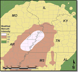
- The New Madrid fault line follows the Mississippi River from Illinois to Arkansas, crossing five state lines – Illinois, Missouri, Arkansas, Kentucky, and Tennessee – as well as the Mississippi River in at least three places.
- The New Madrid seismic zone consists of a series of faults, including fault lines that run up toward the Great Lakes and from the center of the Gulf of Mexico up the East Coast.
Warnings are given regularly
- Earthquakes of increasing intensity
- Earthquake swarms increasing in number
- Sinkholes, shifting roadways, exploding manhole covers, gas explosions, and water main breaks are occurring from Pennsylvania to Tennessee and other areas, as well
- FEMA gearing up with earthquake drills and more for the disaster they know is coming
What size earthquakes can nuclear power plants withstand? There’s no simple answer to that question.
There are 15 nuclear power plants in the New Madrid fault zone, with three of the reactors in Alabama of the same or similar design as the nuclear plant in Fukushima Japan that experienced major problems after a major quake.
How prepared each nuclear plant is for an earthquake, is pretty much what the operators say it is. Jim Norvelle, spokesman of Dominion Virginia Power, says its two reactors were built to withstand ground motion of 0.12 to 0.18 g, which according to Norvelle only translates into magnitudes of 5.9 to 6.2.
Clues that a major quake on the New Madrid approaches
- Repeated blackouts at the Niagara Power Station along the St. Lawrence Seaway
- Quake swarms near Cleveland, Ohio, pointing to a separating Seaway.
- Quakes in the Gulf of Mexico at a previously unknown fault
- Quakes in Maine with water levels falling hard or land rising.
- Methane fields off the coast of Maine releasing large amounts of gas, disrupting the ocean floor and creating massive bubbles
Using the Hurricane Katrina disaster as a guide, be assured that that rescue will not be rapidly forthcoming, if at all.
Self-sufficiency – not government handouts or camps – is the name of the game, and absolutely the key to survival. Get ready. Be prepared.
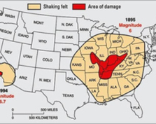
The loss of life and destruction in recent earthquakes of only moderate magnitude (for example, 33 lives and $20 billion in the 1994 magnitude-6.7 Northridge, California earthquake and 5,500 lives and $100 billion in the 1995 magnitude-6.9 Kobe, Japan earthquake) dramatically emphasize the need for residents of the New Madrid Seismic Zone to prepare further for an earthquake of such magnitude. Earthquakes of moderate magnitude occur much more frequently than powerful earthquakes of magnitude 7 to 8, and the probability of a moderate earthquake occurring in the New Madrid Seismic Zone in the near future is high. Scientists estimate that the probability of a magnitude 6.0 or larger earthquake occurring in this seismic zone within any 50 year period is 25% to 40%. Such an earthquake could hit the Mississippi Valley at any time. Sunday, June 17, 2012 Earthquake Details (from usgs.gov)
Magnitude 3.3 Date-Time
M- surface wave magnitude (mbLg), Version=C Source Event ID nm061712a
http://earthquake.usgs.gov/earthquakes/recenteqsus/Quakes/nm061712a.php There is broad agreement in the scientific community that a continuing concern exists for a major destructive earthquake in the New Madrid seismic zone. Many structures in Memphis, Tenn., St. Louis, Mo., and other communities in the central Mississippi River Valley region are vulnerable and at risk from severe ground shaking. This assessment is based on decades of research on New Madrid earthquakes and related phenomena by dozens of Federal, university, State, and consulting earth scientists. Considerable interest has developed recently from media reports that the New Madrid seismic zone may be shutting down. These reports stem from published research using global positioning system (GPS) instruments with results of geodetic measurements of strain in the Earth’s crust. Because of a lack of measurable strain at the surface in some areas of the seismic zone over the past 14 years, arguments have been advanced that there is no buildup of stress at depth within the New Madrid seismic zone and that the zone may no longer pose a significant hazard. As part of the consensus-building process used to develop the national seismic hazard maps, the U.S. Geological Survey (USGS) convened a workshop of experts in 2006 to evaluate the latest findings in earthquake hazards in the Eastern United States. These experts considered the GPS data from New Madrid available at that time that also showed little to no ground movement at the surface. The experts did not find the GPS data to be a convincing reason to lower the assessment of earthquake hazard in the New Madrid region, especially in light of the many other types of data that are used to construct the hazard assessment, several of which are described here.
http://pubs.usgs.gov/fs/2009/3071/pdf/FS09-3071.pdf
- This event has been reviewed by a seismologist.
Magnitude 3.3 Date-Time
- Sunday, June 17, 2012 at 13:40:31 UTC
- Sunday, June 17, 2012 at 08:40:31 AM at epicenter
- Time of Earthquake in other Time Zones
- 6 km (4 miles) NW (308°) from Tiptonville, TN
- 12 km (8 miles) E (82°) from Hayward, MO
- 14 km (9 miles) SSE (148°) from Marston, MO
- 43 km (27 miles) NNW (342°) from Dyersburg, TN
- 149 km (93 miles) NNE (15°) from Memphis, TN
- 254 km (158 miles) SSE (165°) from St. Louis, MO
M- surface wave magnitude (mbLg), Version=C Source Event ID nm061712a
http://earthquake.usgs.gov/earthquakes/recenteqsus/Quakes/nm061712a.php There is broad agreement in the scientific community that a continuing concern exists for a major destructive earthquake in the New Madrid seismic zone. Many structures in Memphis, Tenn., St. Louis, Mo., and other communities in the central Mississippi River Valley region are vulnerable and at risk from severe ground shaking. This assessment is based on decades of research on New Madrid earthquakes and related phenomena by dozens of Federal, university, State, and consulting earth scientists. Considerable interest has developed recently from media reports that the New Madrid seismic zone may be shutting down. These reports stem from published research using global positioning system (GPS) instruments with results of geodetic measurements of strain in the Earth’s crust. Because of a lack of measurable strain at the surface in some areas of the seismic zone over the past 14 years, arguments have been advanced that there is no buildup of stress at depth within the New Madrid seismic zone and that the zone may no longer pose a significant hazard. As part of the consensus-building process used to develop the national seismic hazard maps, the U.S. Geological Survey (USGS) convened a workshop of experts in 2006 to evaluate the latest findings in earthquake hazards in the Eastern United States. These experts considered the GPS data from New Madrid available at that time that also showed little to no ground movement at the surface. The experts did not find the GPS data to be a convincing reason to lower the assessment of earthquake hazard in the New Madrid region, especially in light of the many other types of data that are used to construct the hazard assessment, several of which are described here.
http://pubs.usgs.gov/fs/2009/3071/pdf/FS09-3071.pdf


 RSS Feed
